Shaded headwater stream, Rathburn Run in Ohio, USA
_th place in Biotope Aquarium Design Contest 2020
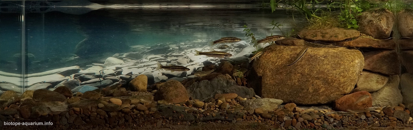
Volume: 80 liters
Dimensions: 90x30x30 cm
List of fishes: Etheostoma caeruleum (Rainbow Darter), Etheostoma nigrum (Johnny Darter), Rhinichthys obtusus (Western Blacknose Dace)
List of plants: Ludwigia palustris, Carex vulpinoidea (fox sedge), Symphyotrichum boreale (Northern Bog Aster)
Description of decorations: Collected directly from the referenced headwater stream, the substrate is comprised of gravel with small amounts of gray sand and silt. Both Small (60-120mm) and large (12-250mm) cobbles are present.Some stones can easily break apart producing silts and sediments, while others are much harder and may only erode into sands. The shape and colors of gravel and cobbles provide an accurate representation of the referenced stream. Emergent plants represent the stream margin. The background photo was taken underwater in the reference stream and enhances the depth and natural feeling of the biotope.
Description of equipment: Flow is produced by an Oase Biomaster Thermo 250 (heater not used) and an Eheim Skim 350, which provides additional oxygenation. A Fluval plant 2.0 provides suspended LED lighting. The tank is an Ultum Nature Systems 90L, high clarity aquarium.
Water parameters: The water temperature varies seasonally with the room from 20-25°C. Hardness and alkalinity are controlled by the local municipal water supply (tap water) but fit within the natural biotope’s ranges. Nutrients are kept low through weekly water changes.
Additional info: 50% water changes are done weekly with cool water. Plants are not fertilized.
INFORMATION ABOUT BIOTOPE:
Description of the area surrounding the biotope: Rathburn Run is a small 7.4 km headwater stream located in Wayne County Ohio, USA with a watershed area of approximately 16 km2 (Krolczyk). Rathburn Run discharges to Little Killbuck Creek which feeds the Muskingum Basin in Ohio. Water flowing through the Muskingum river eventually meets the Ohio River, within the USA’s largest drainage basins, the Mississippi. Rathburn Run is a class III headwater stream. It is primarily groundwater fed, staying inundated and cool throughout the entire year. In this region, yearly rainfall averages 990mm with a dry season August-October. The underlying bedrock of the area is mix sand and shale formations (Sanders). A web soil survey shows soils are mostly silt loams with 2-6 percent slopes (WebSoilSurvey). Forested regions closer to the steam bed have increased moderate to steep sloped topography. Rathburn Run’s stream bed is partially located within an ~2 km2 forested park used for recreational hiking. Outside the park, the land use within the watershed is largely agriculture with minor forested private/municipal land. The gravel stream bed has lightly vegetated mix margins of sand/mud/silt. Deciduous trees are found on or near the bank shading the forested sections of the stream. Fallen trees create log jams and submerged wood habitat with occasional leaf packs. In addition to aquatic life, larger terrestrial species including deer, raccoon, rodents (rabbit, squirrel, chipmunk), fox, snakes, and a variety of birds can be found within the watershed.
Description of the underwater landscape of the biotope: Water depth varies seasonally, with flow greatly reduced in the dry months. Most pools are less than a meter deep and stay inundated throughout the year, while runs may reduce to a slow trickle in the dry months. The water is clear with little silts. The stream bed is comprised of small and large cobbles and boulders. Most of the substrate is loosely compiled, with only a few of the larger cobbles or boulders being embedded in the sandy earth below. Fallen trees and sticks cause log jams and leaf packs in a few areas through the steam.
Description of the parameters of the habitat: The partially shaded and groundwater fed stream keeps waters cool and temperatures range from 4-24 degrees Celsius seasonally (Davic et al.). The natural geology does not introduce many carbonates to the system, resulting in the pH being controlled by organics and humics. The pH range is typical of a natural system falling between 5.5-7. Low nutrient levels would be expected, however, the influence of agriculture in the watershed results in elevated levels of nitrate and phosphates.
List of fishes and invertebrates occurring in the nature biotope: As a class III headwater stream, Rathburn Run supports a range of aquatic and terrestrial inhabitants. The most sensitive of which may be salamanders. List aquatic inhabitants included: Creek chub (Semotilus atromaculatus), Blacknose dace (Rhinichthys obtusus), Green sun fish (Lepomis cyanellus), White sucker (Catostomus commersonii), Stoneroller minnow (Campostoma anomalum), S. Redbelly dace (Chrosomus erythrogaster), Bluntnose minnow (Pimephales notatus), Bluegill sunfish (Lepomis macrochirus), Fathead minnow (Pimephales promelas), Largemouth bass (Micropterus salmoides), Johnny darter (Etheostoma nigrum), Fantail darter (Etheostoma flabellare), Yellow bullheads (Ameiurus natalis), Silverjaw minnow (Notropis buccatus), Orange throat darter (Etheostoma spectabile), Striped shinner (Luxilus chrysocephalus), Mottled sculpin (Cottus bairdii), Brook stickleback (Culaea inconstans), Rainbow darter (Etheostoma caeruleum), Golden shinner (Notemigonus crysoleucas), Central mudminnow (Umbra limi), Spotfin shinner (Cyprinella spiloptera), Grass pickerel (Esox americanus vermiculatus), Redside dace (Clinostomus elongatus), Brown trout (Salmo trutta), Four-toed salamander (Hemidactylium scutatum), Northern longtail salamander (Eurycea longicauda), Crayfish (Decapoda) and over 30 common taxa of macroinvertebrates (Division of Surface Water) (Ohio EPA).
List of plants found in the nature biotope: Stream margins are mixed coverage of wooded and wetland vegetation. The dominant deciduous tree outside the stream bank is the American sycamore (Platanus occidentalis). Small grass like plants including luwigia, sedges, willow and asters maybe found along the margins as well.
Threats to the ecology: Headwater streams provide many benefits to the environment including sediment, nutrient and flood control, wildlife corridors and downstream food supply. Throughout Ohio, nearly every person is located within a short distance from a headwater stream. Due to this close proximity, these steams provide great recreational areas, however, human activities threaten these ecosystems (EPA Ohio). The leading threats to headwater streams are habitat alterations, organic enrichment, siltation, flow alterations and nutrient eutrophication. With streams located so close to homes, habitat and land alterations, such as tree clearing, are common and negatively impact these systems ability to perform their ecosystem functions. Improperly managed land modifications often lead to siltation and sediment runoff, preventing many aquatic species from effectively reproducing. This results in a loss of biodiversity within the streams and a loss of food supply for down stream and non-aquatic creatures. Urban/suburban sprawl often includes hydraulic changes to headwater streams via channelization or enclosing in culverts. This removes water from the systems much quicker and leads to extreme rain event flows followed by reduced base flow. Both of these hydraulic changes cause losses to biodiversity and possibly all aquatic species if the base flow is reduced entirely. Lastly, agricultural is predominate within this region and not only increases sedimentation but causes eutrophication due to excess nutrient runoff. One of the ecosystem functions of headwater streams is nutrient reduction, however, the elevated nutrient levels from non-point source pollution can be overwhelming. Excess nutrients pass through these headwater streams causing further eutrophication in downstream water ways. Overall, anthropogenic impacts lead to reductions in ecosystem function and degradation of larger streams. Negative impacts also result in economic costs, decreased wildlife habitat and additional consequences (aesthetics, flooding, property damaged and erosion) (Ohio Environmental Protection Agency).
Sources of information:
Davic, Robert D., et al. Headwater Stream Initiative.
Division of Surface Water. “Technical Report : Ohio ’ s Primary Headwater Streams- Fish and Amphibian Assemblages.” Ohio EPA, no. September, 2002.
EPA Ohio. Economic Reasons for Sound Management of Primary Headwater Streams. no. May, 2015.
Krolczyk, J. C. Gazetteer of Ohio Streams. no. Second Edition Water Inventory Report 29, 2001.
Ohio Environmental Protection Agency. Clean Rivers Spring from Their Source:The Importance & Management of Headwater Streams. no. August, 2001.
Ohio EPA. “Technical Report: Ohio’s Primary Headwater Streams- Macroinvertebrate Assemblages.” Ohio EPA Division of Surface Water, Columbus, Ohio, no. September, 2002.
Sanders, Randall E. “A Guide to Ohio Streams.” ODNR & Streams Committee, Ohio Chapter of the American Fisheries Society, 2001.
Web Soil Survey: Soil Survey Staff, Natural Resources Conservation Service, United States Department of Agriculture.