Sandy bottom of Lake Tanganyika, Magambo, Tanzania
_st place in Biotope Aquarium Design Contest 2022
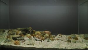
Volume of aquarium: 61 Liters
Dimensions of aquarium: 50x35x35
List of fishes: Lamprologus ocellatus
List of plants: No plants; there is some algae.
Description of Decorations and Substrate: An aquarium representing the Magomba shores of Lake Tanganyika. The bottom is fine sand, some rock, and empty snail shells. Empty shells and sandy areas were chosen similar to those in the habitat.
Description of Equipment: 400 H/L filter, 6500K 8W led lamp, Jbl 50W heater.
Water Parameters: 25 °C temperature, 390 ppm TDS, 8.6 pH, 12 kH.
Additional Info: Weekly water changes and tank maintenance are done. Fish are fed with live food and quality dry food.
Aquarium video:
Description of the Area Surrounding the Biotope: Lake Tanganyika is situated within the Albertine Rift, the western branch of the East African Rift, and is confined by the mountainous walls of the valley. It is the largest rift lake in Africa and the second-largest lake by volume in the world. It is the deepest lake in Africa and holds the greatest volume of fresh water, accounting for 16% of the world’s available fresh water. It extends for 676 km (420 mi) in a general north–south direction and averages 50 km (31 mi) in width. The lake covers 32,900 km2 (12,700 sq mi), with a shoreline of 1,828 km (1,136 mi), a mean depth of 570 m (1,870 ft) and a maximum depth of 1,471 m (4,826 ft) (in the northern basin). It holds an estimated 18,900 km3 (4,500 cu mi).
The catchment area of the lake is 231,000 km2 (89,000 sq mi). Two main rivers flow into the lake, as well as numerous smaller rivers and streams (whose lengths are limited by the steep mountains around the lake). The one major outflow is the Lukuga River, which empties into the Congo River drainage. Precipitation and evaporation play a greater role than the rivers. At least 90% of the water influx is from rain falling on the lake’s surface and at least 90% of the water loss is from direct evaporation.
The major river flowing into the lake is the Ruzizi River, formed about 10,000 years ago, which enters the north of the lake from Lake Kivu.The Malagarasi River, which is Tanzania’s second largest river, enters the east side of Lake Tanganyika.[10] The Malagarasi is older than Lake Tanganyika, and before the lake was formed, it probably was a headwater of the Lualaba River, the main Congo River headstream.
The lake has a complex history of changing flow patterns, due to its high altitude, great depth, slow rate of refill, and mountainous location in a turbulently volcanic area that has undergone climate changes. Apparently, it has rarely in the past had an outflow to the sea. It has been described as “practically endorheic” for this reason. The lake’s connection to the sea is dependent on a high water level allowing water to overflow out of the lake through the Lukuga River into the Congo.[10] When not overflowing, the lake’s exit into the Lukuga River typically is blocked by sand bars and masses of weed, and instead this river depends on its own tributaries, especially the Niemba River, to maintain a flow.
Due to the lake’s tropical location, it has a high rate of evaporation. Thus, it depends on a high inflow through the Ruzizi out of Lake Kivu to keep the lake high enough to overflow. This outflow is apparently not more than 12,000 years old, and resulted from lava flows blocking and diverting the Kivu basin’s previous outflow into Lake Edward and then the Nile system, and diverting it to Lake Tanganyika. Signs of ancient shorelines indicate that at times, Tanganyika may have been up to 300 m (980 ft) lower than its present surface level, with no outlet to the sea. Even its current outlet is intermittent, thus may not have been operating when first visited by Western explorers in 1858.
The lake may also have at times had different inflows and outflows; inward flows from a higher Lake Rukwa, access to Lake Malawi and an exit route to the Nile have all been proposed to have existed at some point in the lake’s history.
Lake Tanganyika is an ancient lake. Its three basins, which in periods with much lower water levels were separate lakes, are of different ages. The central began to form 9–12 million years ago (Mya), the northern 7–8 Mya and the southern 2–4 Mya.
Description of the Underwater Landscape of the Biotope: This aquarium was made to represent the coastline of the town of Magombo, Tanzania. The habitat of Lamprologus ocellatus, one of the shell dwellers, was discussed. It simulates a sandy and slightly sedimented area.
Description of the Habitat Parameters: The water in Lake Tanganyika is alkaline, with a pH between 8.5 – 9.0 depending on the depth and alkalinity surrounding the 650µS. The water temperature of the lake is very stable, due to the large body of water. The surface temperature of Lake Tanganyika ranges from 23-27°C, and the hypolimnion temperatura ranges from 23–24°C, although most fish inhabit areas with a temperature of 24-27°C.
List of Fishes and Invertebrates Occurring in the Nature Biotope: Altolamprologus sp. “Sumbu” (Boulenger, 1898), Lamprologus ocellatus (Steindachner, 1909), Lepidiolamprologus cunningtoni (Boulenger, 1906), Neolamprologus multifasciatus (Boulenger, 1906), Neolamprologus tetracanthus (Boulenger, 1899), Telmatochromis temporalis (Boulenger, 1898)
List of Plants Found in the Nature Biotope: There are no plants in this biotope.
Threats to the Ecology of the Biotope: The pollution from excessive sediment and nutrient loads caused by erosion in the watershed, industrial and urban waste,
The intensive fishing using inappropriate methods, and
The human activities (constructions, agriculture, etc.) in the littoral zone of the lake that destroy the buffer zones which also serve as fish spawning areas.
Sources of Information:
http://www.tanganyika.si/Tanganjika/Lamprologus/Lamprologus%20ocellatus/index.html
https://www.globalnature.org/en/living-lakes/threatened-lake-2017/interview
https://en.wikipedia.org/wiki/Lake_Tanganyika
Youtube videos and region images