Quanquan Pool, fault at the headwaters of Xianghe River in Qinling Mountains, Xi’an, China
_st place in Biotope Aquarium Design Contest 2022
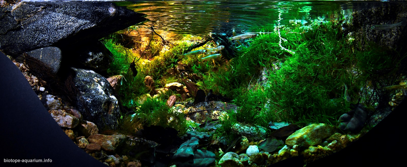
Volume of aquarium: 90L
Dimensions of aquarium: 60x50x30cm
List of fishes: Rhynchocypris lagowskii
Neocaridina sp.
List of plants: Dicranum sp., Meteorium sp., Plagiomnium sp., Hypnum sp., Taxiphyllum sp., Myuroclada sp.
Description of Decorations and Substrate: All the materials (rocks, branches, dry leaves, etc.) used in the work I create are from nature. In order to create the most realistic effect in the original environment and confuse the eyes of the fish, I used the same granite gneiss and other rocks as the original environment; for the use of plants, I went back and forth for more than 2,000 kilometers. Collect local native plants in situ (please be assured, this is a proper collection, it will not cause damage to the habitat, and no cherished or protected plants have been collected) and apply them; in terms of stone placement, I used a very special layout method to imitate the common and characteristic landslide landforms in the area. For example, the largest stone on the left, a large part of which is suspended in the air, is very common due to the local landslide landform; another example is the relatively flat rock mass on the right, which is also a typical product of landslides.
Description of Equipment: ODYSSEA ADV 150W, YEE YNM-005×7, KaiserREEF mini 6500K, EHEIM600+SUNSUN EW-604, HAILA chiller HS-28A, Chihiros DOCTOR 2, CORALIFE Turbo-Twist 3x UV germicidal lamp, MUFAN CO2 system
Water Parameters: 15℃, about 27PPM, PH7.5, clear and transparent
Additional Info:Through a mature and reasonable maintenance management system and the use of the same materials as the original site, this work almost perfectly restores the water quality of the original site – the water in the tank is clean and cool. It is precisely controlled at 15℃, the conductivity is controlled at about 27PPM through the filtration system and water exchange, and the pH is controlled at 7.5.
Aquarium video::
https://mab.to/ZLKmR1i52
Description of the Area Surrounding the Biotope: The Qinling Mountains, respected as the dragon vein of Chinese civilization, lie in the hinterland of our country. The towering body separates the south and the north, and draws the important Qinling-Huaihe line. The main ridge of the mountain is on the north side, the north slope is short and steep, and the river is deep, forming many canyons, commonly known as the “Seventy-two Valleys” of the Qinling Mountains. Among them, there is a valley where auspicious clouds often appear. It is said that this is still the Guanyin Dojo. Once the poet Li Bai came here to visit… The blessings of various legends and stories make this place even more mysterious and legendary. Going back to the depths of Yuyu, I saw a ray of sunset pierced through the canopy of trees and hit a stone crevice; spring water emerged from the stone crevice, splashed out, grew all the way, and turned into a river. The journey was thirty. inside. A rare ray of sunset in the forest hit the fountain at the source of the river. This is a coincidence, but it seems inevitable. The river channels here are often covered with emerald moss, especially the source of the best water quality, which is a very rare plant community in the wild aquatic habitat. In this way, all kinds of rare conditions converge here, creating this unique and legendary habitat. This is the source of “Seventy-two Valleys” – Xiangyu (the river name “Xiang River”). The water depth of this habitat does not exceed 60 cm, and the average depth is only about 40 cm. Such water is clean and cool, the water temperature is only 15℃, and the conductivity is only 27PPM. The water here is slightly alkaline, with a pH of 7.5. The Xianghe River belongs to the Fenghe River System, with a total length of about 15 kilometers. The northern foot of Qinling Mountains in Shaanxi Province, where it is located, is located between the main ridge of Qinling Mountains and the southern margin of the Guanzhong Plain, with an average width of less than 30 km. The northern foot of Qinling Mountains belongs to the warm temperate monsoon climate zone with four distinct seasons. The vertical climate zone is obvious, the high mountain area is cold and humid, with an annual average temperature of 6-8°C, which is the distribution area of high precipitation value; the low mountains and river valleys are warm and rainy, with an annual average temperature of 11-14°C and an annual precipitation of about 700 mm. . The rivers at the northern foot of the Qinling Mountains in Shaanxi Province have short sources, steep slopes, clear water and rapid flow. Most of the tributaries of the Weihe River at the northern foot of the Qinling Mountains are feather-shaped and almost perpendicular to the Weihe River, and most of them are single-branched water systems. In the flood season, when flash floods occur, the floods carry rolling stones, gravel and pebbles and pour out, forming alluvial fans or estuary deltas. The tectonic range of the fault zone at the northern foot of the Qinling Mountains is the junction of the Sino-Korean quasi-platform and the Qinling fold system. From the perspective of secondary tectonic position, it is located at the junction of the southern edge of the Weihe fault depression belt and the Qinling orogenic belt, and has experienced many processes of deformation, displacement, aggregation and extension in the development and evolution of geological structures. The mountainous landforms mainly include Qinling Mountains and Lishan Mountains. The Qinling Mountains stretch and stand on the southern edge of the Weihe Basin. The mountains are steep in the north and gentle in the south, high in the west and low in the east. They are based on folds. The middle and high mountains formed by the lifting of the upper fault block, the highest peak of Taibai Mountain is 3676 m above sea level, and the general altitude is 1500-3000 m. Many rivers on the northern slope of the Qinling Mountains have a valley structure, that is, the upper part is a gentle U-shaped valley, and the lower part is a V-shaped valley. Lishan Mountain is a fault block mountain in the Weihe Basin. It is steep in the north and gentle in the south. The highest peak is 1302m above sea level. The piedmont proluvial fan on the northern slope is superimposed and developed, extending to the Wei River and covering the river terrace; The Qinling Mountains, which are the natural separation zone between the north and the south of my country, can be divided into three sections: the west, the middle and the east in terms of geology and geomorphology: the Taibai Mountain block in the west, and the Zhongnan Mountain section in the middle (the source of the Xianghe River imitated in the work is located in this area all over the place). The northern foot of the mountain) and the east is the Huashan block. Throughout the ages, most people in the society have recognized that Zhongnan Shanxi starts from the Luoyu River in Zhouzhi County in the east to the Liuyu River in Lantian County, or slightly northeast to Paigouyu. The northern foot of Zhongnan Mountain is also divided into three sections by ordinary people, which are basically divided according to administrative divisions, namely: Lantian section (eastern section), Chang’an section (middle section), and Huxian-Zhouzhi section (western section). The ecological system at the northern foot of Zhongnan Mountain is diverse and complete, with distinct characteristics, extremely rich ecotourism resources, and has great potential for the development of ecotourism. Such as the granite peaks and ridge landforms of Nanwutai and Wangshun Mountain, the landslide and dammed lake of Cuihua Mountain, the Wangchuan Karst Cave with “the scenery is like Penglai, the cave is like a sea palace”, and the waterfalls hanging from the upper source of rivers and streams; Many natural landscapes such as hot springs distributed in Zhouzhi are full of praise, and have a very important position in the development pattern of Xi’an’s tourism industry. In addition, there are abundant humanistic eco-tourism resources at the northern foot of Zhongnan Mountain. “Chang’an has been an imperial capital since ancient times”, Xi’an is one of the ancient cities in China, with rich ancient cultural relics. Among the cultures left over in Xi’an, there are palace ruins that reflect the rise and fall of different dynasties and tombs of emperors of various dynasties; there are also books and art treasures that reflect the cultures of different periods; some are temple complexes characterized by religious culture; there are also precious cultural relics In this way, the sites and artifacts that reflect the history of human development and evolution. The cultural landscape embodies the profound cultural accumulation, enriches and deepens the content of tourism activities, deepens the spiritual feeling of tourists, and is influenced by knowledge. In terms of natural conditions, the source of the Xianghe River is located in the transitional zone where plants meet in the north and south of China. There are both North China and Central China flora components, as well as the Qinghai-Tibet Plateau flora components. There are more than 800 kinds of seed plants in the area, many of which are the world’s single species, few species and China’s endemic plants. There are more than 20 kinds of rare and endangered plants under national key protection: Taibai red cedar, green sandalwood, water green tree, lianxiang tree, collar spring wood, Qinling fir, weeping spruce, single leaf grass, gastrodia elata, and wild soybean. There are deciduous oak forest landscape belt, birch forest landscape belt and fir forest landscape belt distributed from bottom to top according to the altitude. The unique geographical location and good forest ecosystem provide conditions for wild animals to live and multiply. Because this area is located at the boundary between the Palaearctic and Oriental animals, it has nurtured a variety of wild animal species. According to previous records, there are more than 250 kinds of wild animals, including more than 160 kinds of birds, more than 70 kinds of beasts, more than 20 kinds of amphibians and reptiles, and a large number of forest insects. There are more than 20 species of precious wild animals under national key protection, including giant panda, golden monkey, takin, leopard, serow, green sheep, forest musk deer, golden pheasant, red-bellied pheasant and giant salamander.
Description of the Underwater Landscape of the Biotope: In the evening, a ray of sunset pierced through the canopy of trees and hit a stone crevice; spring water emerged from the stone crevice and splashed out, and the Thirty Mile Xianghe River originated from here. The rivers here are often covered with green moss, especially the source with the best water quality – the high water replacement efficiency of the source spring pool keeps the water quality here in an excellent state, which is very rare in wild aquatic habitats plant community. Beautiful aquatic moss, sparkling water surface, clean white sand, highly textured dead branches and fallen leaves in the spring pool, warm and cool colors complement each other, even the grass tanks in the top competitions seem to be incomparable. Such an excellent habitat also breeds many aquatic creatures, and even the entire ecology of Xiangyu in the Qinling Mountains.
Description of the Habitat Parameters: 15℃, about 27PPM, PH7.5, clear and transparent
List of Fishes and Invertebrates Occurring in the Nature Biotope: Rhynchocypris lagowskii
Neocaridina sp.
List of Plants Found in the Nature Biotope: Dicranum sp.
Meteorium sp.
Plagiomnium sp.
Hypnum sp.
Taxiphyllum sp.
Myuroclada sp.
Threats to the Ecology of the Biotope: none
Sources of Information:
1. https://m.weibo.cn/c/novelty/detail?card_id=7582444582150145
2. https://m.weibo.cn/6249947943/4482337456956246
3. 植物智.
4. 水面之下是梦境4,张力弦,新浪微博头条文章@少年ZLX
5. 水面之下是梦境5,张力弦,新浪微博头条文章@少年ZLX
6. 野生水生植物记 水生苔藓(水下叶moss) 概述,张力弦,新浪微博头条文章@少年ZLX
7. 百度百科.
8. 章丘泉旅游差异性开发研究 高翔 1 李军辉 1 王媛 1 张雪 1
9. 保护好百脉泉这份自然遗产 王茂修
10. 百脉泉群断流及明水泉群水资源保护的探讨 章丘市环境保护监测站 李媛媛 孟宪红 章丘市水利局 李雅静
11. 影响百脉泉喷涌因素浅析 袁传芳 刘 伟 刘永红 曹元青
12. 应用SPSS分析降水年际年内变化对泉水动态影响——以济南明水泉域百脉泉群为例 于翠翠 1, 2 陈瑞恒 2 胡思敬 2 魏金钊 2( 1.山东省地质测绘院, 山东济南250014 2.山东省地矿工程集团有限公司, 山东济南250200 )
13. 煤矿开采对明水泉的影响浅析 袁传芳,张运区,逯志强(章丘市水务局,山东 章丘)
14. 水生植物在滨水景观中的应用研究———以济南市明水泉域水生植物配置为例 刘艳红 1, 张 显1, 许宪刚2( 1.西北农林科技大学, 陕西杨凌 712100; 2.山东省章丘市园林局, 山东章丘 250200)
15. 探析我国水资源利用现状及开发利用———以山东省章丘市为例 陈 悦 蔡 萍( 北京理工大学 管理与经济学院,北京 100081; 章丘市水务局,山东 济南 250200)
16. 大数据在章丘区泉水保护工作中的应用 马秀芸 1,张扩成 2(1.济南市章丘区城乡水务局,山东 济南 250200;2.山东济南市邢家渡引黄灌溉管理处,山东 济南 250000)
17. 百脉泉泉群流量动态特征及影响因素分析 崔爱萍 1 于翠翠 2 ( 1.山东科技大学地球科学与工程学院, 山东青岛266590 2.山东省地矿工程集团有限公司, 山东济南250014
18. 章丘市泉群保护与泉水资源利用工程 刘永红, 郑萍萍, 周明春( 章丘市水利局, 山东 济南 250200)
19. 水生植物在济南地区的引种应用初报 王吉栋 1( 1.济南市中山公园管理处 )济南春季鱼类群落与水环境因子的关系 朱中竹1,王 瑾1,宋瑞华1,王博涵2,殷旭旺2(1.济南市水文局,山东 济南 250014;2.大连海洋大学,水产与生命学院,辽宁省水生生物学重点实验室,辽宁 大连 116023)
20. 大气降水与济南泉水动态变化的定量关系研究 迟光耀1,邢立亭1,主恒祥1,侯新宇1,相 华2,邢学睿3( 1. 济南大学 资源与环境学院,山东 济南 250022; 2. 山东省济南市水文局,山东 济南 250013; 3. 河北地质大学,河北 石家庄 050031)
21. 水样的采集方法研究——以黑虎泉泉水为例 赖英麟 1 迟双会 2( 1.山东协和学院, 山东济南250000 )
22. 济南泉域岩溶系统碳循环 陈鸿汉① 董 英②张永祥②(①中国地质大学环境科学系 ,北京 100083; ②长春科技大学环建学院 ,长春 120026)
23. 济南泉域岩溶水水化学特征及其成因王珺瑜 1, 2 王家乐 1, 2, 3 靳孟贵 1, 2( 1.中国地质大学盆地水文过程与湿地生态恢复学术创新基地, 湖北武汉430074 2.中国地质大学环境学院, 湖北武汉430074 3.长江科学院水土保持研究所, 湖北武汉430010 )
24. 秦岭藓类植物的群落,《西北植物学报》,张满祥,1988
25. 秦岭地区苔类植物区系的初步研究,陈清,王玛丽,张满祥
26. 山东省苔藓植物的生物多样性特征及保护:衣艳君
27. 黔中瀑布水生苔藓植物区系及其生物喀斯特沉积生态类型研究,张朝晖,陈家宽
28. 山东省昆嵛山苔藓植物研究,黄正莉,2012
29. 生物与自然保护苔藓.苔藓生物与自然保护.2006-03-10
30. 论藓类植物适应环境的形态与解剖学基础,杨武,郭水良,方芳,2007.8
31. 苔藓植物资源保护利用中的生态环境效应研究进展艾应伟,刘浩,李伟,答竹君,张卫东,周南华,宋婷,2010,《生态环境学报》
32. Zhang, ZH, Chen, J.K. Marchantiophyta and Anthocerophy- ta in Guizhou province, P. R.China[J]. Journal of Bryology, 2006, 28: 170-176.
33. Redfearn PL, Jr., BC.Tan, S.He. A newly updated and an- notated checklist of China mosses [J]. Journal of Hattori Botanical Laboratory, 1996, 79:163-357.
34. 几种观赏苔藓植物对水体环境的适应和组织培养研究,李倩,2013,4
35. 吴鹏程, 罗健馨, 汪楣芝.苔藓名词及名称[M].北京:科学出 版社, 1984:1-124.
36. 黄石地区苔藓植物生态群落研究,洪文,2007
37. 法国阿尔卑斯山(Mt.Alps, France))溪流型喀斯特瀑布水生苔藓植物群落生态研究,张朝晖,陈家宽,艾伦.培特客斯,2007·3
38. 山西蟒河自然保护区苔藓植物研究,王桂花,谢树莲,张峰,赵益善,
39. 黔中瀑布水生苔藓植物区系及其生物喀斯特沉积生态类型研究,张朝晖,陈家宽,2007.2
40. 桂西南喀斯特瀑布水生苔藓植物生物多样性与生态沉积类型研究,张朝晖,陈家宽,2007.4
41. 香纸沟苔藓植物多样性及其溪流瀑华沉积研究,彭涛,2006
42. 白云岩洞穴洞口弱光带的苔藓群落特征——以绥阳水洞为例,郭云,王智慧,张朝晖,2018,《中国岩溶》
43. 贵州省施秉喀斯特地区苔藓植物群落类型,李晓娜,2016,《吉林农业》
44. 北京百花山自然保护区苔藓植物多样性研究,田晔林,2011
45. 刘晓玲王强. 重金属对苔藓植物影响的研究进展. 《 CNKI 》
46. 朱秀敏. 苔藓植物化学元素营养富集与开发利用. 《 CNKI 》
47. 田维莉,孙守琴. 苔藓植物生态功能研究新进展. 《 CNKI;WanFang 》
48. 宋闪闪,邵小明. 城市习见苔藓植物——以北京为例. 《 CNKI;WanFang 》
49. 陈钰,向成斌,叶昕. 植物复苏性状的分子机理研究进展. 《 VIP 》
50. 侯宽昭 主编 吴德邻 高蕴璋 陈德昭 等 修订.《中国种子植物科属词典》(第二版). 科学出版社 ,1998年01月1日
51. 《水草造景艺术从入门到精通》,王超
52. 《水草栽培与造景》,白明
53. 《中国常见植物野外识别手册苔藓册 》,马克平
54. 《苔藓植物多样性及其保护 》,曹同 等编著 著作
55. 《山东苔藓志》,任昭杰 ,赵遵田
56. 科普文章|苔藓植物初印象之—云南水生苔藓植物掠影:云南吴征镒科学基金会 ,马文章
57. 秦岭蕨类植物补遗 郭晓思(陕西省、中国科学院西北植物研究所 , 陕西杨陵 712100)
58. 翠华山山崩地貌奇观的成因分析 李昭淑1, 丁冰2, 王涛3( 1.西北大学 城市与资源学系, 陕西 西安 710069;2.陕西省地矿局, 陕西 西安 710068;3.西安市城市建设开发总公司,陕西 西安 710074)
59. 陕西翠华山山崩地貌遗迹特征及其珍稀性 武智远 高文战( 陕西省地矿局西安地质矿产勘查开发院, 西安 710100 )
60. 陕西翠华山山崩及其环境效应 郭力宇1,吴成基1, 甘枝茂1, 徐选举2, 吴新恒2, 赵辉2( 1.陕西师范大学旅游与环境学院, 陕西 西安 710062; 2.西安翠华山旅游发展股份有限公司, 陕西 长安 710105)
61. 天下第一福地——终南山 陕旅
62. 长安县秦岭北麓经济开发带资源保护与综合利用设想 强晓安 (长安县计划委员会,主任 )
63. 基于 SWOT 分析法的终南山北麓生态旅游可持续发展研究 梁静 (西安翻译学院经济管理学院)
64. 西安市城郊休闲旅游发展现状及发展研究——以祥峪沟为例 孙婧 1( 1.西安文理学院文化与旅游学院 )
65. 秦岭北麓水资源利用现状与生态景观维护 蒋建军 1 冯普林 2, 3( 1.陕西省江河水库管理局, 陕西西安710018 2.陕西秦安河流研究所, 陕西西安710018 3.陕西省河流工程技术研究中心, 陕西西安710018 )
66. 秦岭北麓主要河流的水质现状调查与评价 肖玲1, 王书转2, 张健1, 王利军1, 任桂镇1( 1.陕西师范大学旅游与环境学院, 西安 710062; 2.南阳师范学院, 河南 473061)
67. 西安段秦岭北麓旅游水资源承载力 王静1,2,周庆华1( 1. 西安建筑科技大学 建筑学院,陕西 西安 710055; 2. 西安文理学院 经济管理学院,陕西 西安 710065)
68. 试论山东玲珑花岗岩的成因与演化 薛金声 (海洋地质学系)
69. 山东省花岗岩地貌景观的构造分区和典型类型研究 于得芹 1 蒙永辉 2( 1.山东省地质调查院,山东济南250014 2.山东省地质环境监测总站,山东济南250014 )
70. 陕西观音山自然保护区蕨类植物区系研究 慕英1, 李登武1, 2 *, 王冬梅1( 1.西北农林科技大学 林学院, 陕西 杨陵 712100 ;2.西北农林科技大学 西北自然保护区研究中心, 陕西 杨陵 712100)
71. 秦岭造山带光头山岩体群黑云母地球化学特征及成岩意义 张有军 1 梁文天 2 罗先熔 1 董云鹏 2 张国伟 2( 1.广西隐伏金属矿产勘查重点实验室, 桂林理工大学地球科学院, 广西桂林541004 2.大陆动力学国家重点实验室, 西北大学地质学系, 陕西 西安710069 )
72. 秦岭甘峪河鱼类资源现状及保护评析 张建禄1,边坤1,马建林2,苟妮娜1,王开锋1(1.陕西省秦岭珍稀濒危动物保育重点实验室,陕西省动物研究所,陕西 西安 710032;2.户县渔政监督管理站,陕西 西安 710300)
73. 秦岭黑河流域植物区系组成成分、特征分析 王宇超 黎斌 * 李阳 周亚福 李为民 陕西省西安植物园, 西安, 710061
74. 黑河国家级自然保护区秦岭细鳞鲑主要饵料生物——拉氏鱥种群特征及其季节变化 苟妮娜 1 靳铁治 1 张建禄 1 边坤 1 王开锋 1( 1.陕西省秦岭珍稀濒危动物保育重点实验室陕西省动物研究所, 西安710032 )
75. 渭河流域鱼类群落结构特征及其受环境因子的影响分析 武玮 1 徐宗学 1 殷旭旺 2 于松延 1( 1.北京师范大学水科学研究院水沙科学教育部重点实验室, 北京100875 2.大连海洋大学生命科学与技术学院, 大连116023 )
76. 秦岭终南山世界地质公园地质遗迹资源及价值评价*查方勇1,2,郭威1,张健1,杨望暾1,张东薇3,魏梦媛1( 1. 长安大学地球科学与资源学院,西安 710054; 2. 西部矿产资源与工程教育部重点实验室,西安 710054;3. 秦岭终南山世界地质公园管理办公室,西安 710007)
77. 中国水生植物.
78. 中国脊椎动物大全.
79. 太白山自然保护区两栖爬行动物多样性与保护 何晓军` ,赵 芳` ,李先敏` ,梁 刚“( 1 陕西太白山国家级自然保护区管理局,陕西眉县 7 22 30 0;2 陕西师范大学生命科学学院,陕西 西安 71 006 2)
80. 陕西黄柏塬自然保护区两栖动物多样性 郑雪莉 1 卜书海 2 冯学运 2 李旭辉 2( 1.西北农林科技大学林学院, 陕西杨陵712100 2.西北农林科技大学生命科学学院, 陕西杨陵712100 )