Little part Orinoco River basin. Morichal Morganito, Venuezela
_st place in Biotope Aquarium Design Contest 2022
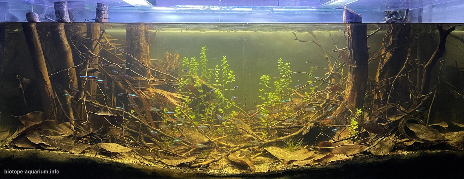
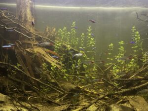
Volume of your aquarium: 240 liters
Dimensions of your aquarium: 120x40x50cm
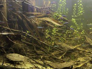
List of fishes: Paracheirodon axelrodi, Carnegiella strigata, Corydoras aeneus, Hemigrammus rhodostomus
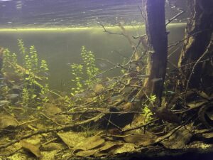
List of plants: Bacopa monnieri , Eleocharis sp
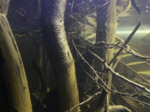
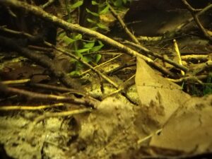
Description of Decorations and Substrate: I used the roots of birch, which very much resembles the base of the trees in this region. The fine sand is very similar to that of the RioOrinoco, palm pod and leaves, magnolia leaves.
Description of Equipment: Filter Sunsun hw403 A (1400l/h), flow pump 500l/h, NICREW classic led 18w 7000k, Heater 200w
Water Parameters: Temperature is 27°C, Ph is 6.2, gH is 5
Additional Info: 50% water change every week by rainwater
Aquarium video::
Description of the Area Surrounding the Biotope: The Morichal Largo River is located in Llanos, north of Venezuela. It takes its name from a woman. In the vicinity are various Morichal Palms and deciduous trees.
Orinoco River, Spanish Río Orinoco, major river of South America that flows in a giant arc for some 1,700 miles (2,740 km) from its source in the Guiana Highlands to its mouth on the Atlantic Ocean. Throughout most of its course it flows through Venezuela, except for a section that forms part of the frontier between Venezuela and Colombia. The Orinoco and its tributaries constitute the northernmost of South America’s four major river systems. Bordered by the Andes Mountains to the west and the north, the Guiana Highlands to the east, and the Amazon watershed to the south, the river basin covers an area of about 366,000 square miles (948,000 square km) It encompasses approximately four-fifths of Venezuela and one-fourth of Colombia. For most of its length, the Orinoco flows through impenetrable rain forest or through the vast grassland (savanna) region of the Llanos (“Plains”), which occupies three-fifths of the Orinoco basin north of the Guaviare River and west of the lower Orinoco River and the Guiana Highlands. Since the 1930s this region has been developing into one of the most industrialized areas of South America. Below the town of Esmeralda, some of the waters of the Orinoco flow south into the Casiquiare River (Brazo Casiquiare; sometimes called the Casiquiare Channel). This channel, a feature peculiar to the Orinoco River system, is a natural passage that flows generally south until it combines with the Guainía River to form the Negro River, thus linking the Orinoco and Amazon river systems. The Llanos encompasses nearly all of the western lower Orinoco basin, occupying some 220,000 square miles; most of the land is less than 1,000 feet above sea level. The High Plains (Llanos Altos) are most conspicuous near the Andes, where they form extensive platforms between rivers and are some 100 to 200 feet above the valley floors. Away from the mountains they are increasingly fragmented, as in the dissected tableland of the central and eastern Llanos (the Sabana de Mesas) and the hill country (serranía) south of the Meta River in Colombia. The Low Plains (Llanos Bajos) are defined by two rivers, the Apure in the north and the Meta in the south. The lowest portion of the Llanos is an area that lies to the west of the lower Orinoco valley; this area is converted annually into an inland lake by flooding. The climate of the Orinoco basin is tropical, with the seasons marked by differences in rainfall rather than in temperature. The year is divided into two seasons—rainy and dry (locally known as winter and summer)—the former extending from April to October or November and the latter most marked from November through March or April. The wet and dry seasons result from the annual migration of the intertropical convergence zone, a low-pressure trough between the hemispheric easterlies, or trade winds; the passage of the zone northward from its summertime position south of the Equator brings the rainy winter period. In contrast to precipitation, temperature differences in the basin are slight throughout the year; and no month averages more than 69 °F (21 °C) or less than 64 °F (18 °C). Whatever the average temperature, there is little difference from month to month. The only marked variation is from day to night, being greater than that from month to month. On the Llanos, daily maximum temperatures rise above 95 °F (35 °C) in the dry period; the dry winds and nocturnal cooling bring relief with normal minimum temperatures between 65 and 75 °F (18 and 24 °C). More than 1,000 species of birds frequent the Orinoco region; among the more spectacular are the scarlet ibis, the bellbird, the umbrella bird, and numerous parrots. The great variety of fish include the carnivorous piranha, the electric eel, and the laulao, a catfish that often attains a weight of more than 200 pounds. The Orinoco crocodile is one of the longest of its kind in the world, reaching a length of more than 20 feet. Among other inhabitants of the rivers are caimans (an alligator-like reptile) and snakes, including the boa constrictor. The arrau, or side-necked turtle, the shell of which grows to a length of about 30 inches, nests on the sandy islands of the river. Insects include butterflies, beetles, ants, and mound-building termites.
Description of the Underwater Landscape of the Biotope: Venezuela, Bolivarian Republic of, Amazonas
Morichales get their name from the Moriche Palm (Mauritia flexuosa) which is a palm which only grows and thrives where its roots can be underwater. Morichales is just the name given in Spanish to a large group of Moriche Palms.
As Morichales usually get their water from underground water springs, they maintain the crystal clear water all year round. They are places teeming with life where we find one of the highest concentrations of animal and plant species.
It is very difficult to find small or medium size rocks; rather, its rocks are the size of a football field. It is an environment comparable to the oasis in the desert where you only see sand and suddenly you come across of a wooden area full of water and life but in this case you will see plains of tall grass and suddenly find this tropical forests full of palm, trees and marsh plants.
The place where they are located is so flat that if you had an eagle’s eye view you could cross from Colombia to Venezuela. These springs, the Morichales, are the arteries that carry their waters to the main channel, the colossal Orinoco River and serve as habitat for small fish such as tetras and Apistogramma, where large predators feed and where their small fry grow to maturity.
Description of the Habitat Parameters: Water information
Water type : Fresh water
Water color : Clear water or clear amber water
Water transparency : High
Concentration of sediments : No
Water temperature : 26-30 °C
Water flow/curent : Slow
Chemical parameters
pH 6.0
Conductivity : GH 6 mg/l
KH 7 mg/l
List of Fishes and Invertebrates Occurring in the Nature Biotope: Acestrorhynchus falcatus, Acestrorhynchus microlepis, Gnathocharax steindachneri, Heterocharax virgulatus, Paracheirodon axelrodi , Anostomus ternetzi, Apistogramma guttata, Sternarchorhynchus mendesi, Mesonauta Insignis, Mikrogeophagus Ramirezi, Paracheirodon Simulans, Hemigrammus rhodostomus , Cichlasoma Bimaculatum, Corydoras aeneus, Crenicichla sp., Heros Severus, Hoplias Malabaricus, Nannostomus sp., Rineloricaria sp., Carnegiella strigata, Ancistrus sp.
List of Plants Found in the Nature Biotope: Phyllanthus Fluitans, Egeria Densa, Pistia Stratiotes, Bacopa monnieri, Ceratophyllum Demersum, Salvinia Auriculata, Sagittaria Subulata, Hydrocotyle Leucocephala, Echinodorus sp., Cabomba Aquatica, Pistia Stratiotes, Mayaca Fluviatilis, Eleocharis sp
Threats to the Ecology of the Biotope: Abundant water in the Orinoco River Basin supports the needs of people, agriculture, energy and industry (oil and gas) that are vital for Colombia’s social and economic development. But the basin faces increasing pressures from the expansion of mining (942 concessions for 2014), oil and gas (8 million ha under exploration), agro-industry (320,829 ha), and infrastructure, which if not adequately planned and implemented can disrupt the hydrology and ecosystem services of the region. Additionally, the Orinoco Basin’s seasonal rainfall patterns will potentially face further extremes and unpredictability from climate change, leading to greater droughts, flooding, and fires. Maintaining the health of the Orinoco River Basin is vital to support adequate water and services critical for people, the economy, and nature.
Sources of Information:
Region information:
https://www.britannica.com/place/Orinoco-River
https://en.m.wikipedia.org/wiki/Orinoco
https://www.mikolji.com/articles/exploring-a-morichal/
https://wwf.panda.org/knowledge_hub/where_we_work/orinoco_river_basin/
Fish and plant list:
Paracheirodon axelrodi – Cardinal Tetra (Cheirodon axelrodi, Hyphessobrycon cardinalis)
https://www.seriouslyfish.com/species/carnegiella-strigata/
https://www.seriouslyfish.com/species/corydoras-aeneus/
https://www.seriouslyfish.com/species/hemigrammus-rhodostomus/
https://www.fishbase.se/Country/CountryChecklist.php?showAll=yes&what=list&trpp=50&c_code=862&sortby=alpha&ext_CL=on&ext_pic=on&vhabitat=fresh
https://aquatic-experts.com/ESPANOL/PLANTAS_DE_AGUA_DULCE_ES.html