Rio Aiuana Small Forest Creek, A Tributary of the Rio Negro. Santa Isabel-Brazil
_st place in Biotope Aquarium Design Contest 2022
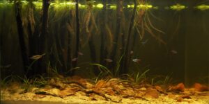
Volume of aquarium: 84 liters
Dimensions of aquarium: 60x40x35
List of fishes: Apistogramma mendezi (Santa Isabel), Paracheirodon axelrodi.
List of plants: Echinodorus tenellus, Limnobium laevigatum.
Description of Decorations and Substrate: Vertical pieces of wood representing young trees were used to simulate the flooded forest floor. The base is finished with light fine sand and dry leaves. Every material representing a still water stream resembles a habitat.
Description of Equipment: Dophin cf-300 brand external filter, Jbl 300 watt heater, 20 watt-6 K led lighting.
Water Parameters: Temperature 25 °C, pH 4.9, Tds 23 ppm, kH 0, Nitrate 0-5 mg.
Additional Info: Regular water changes and maintenance are done every two weeks. Black water additive is used in the peat and change water in the filter. The water changes of the tank are provided with ro water.
Aquarium video:
https://disk.yandex.com.tr/i/RlcX686psY2WGg
Description of the Area Surrounding the Biotope: The Rio Negro (Portuguese: Rio Negro [ˈʁi.u neɡɾu]; Spanish: Río Negro [ˈri.o ˈneɣɾo] “Black River”), or Guainía as it is known in its upper part, is the largest left tributary of the Amazon River (accounting for about 14% of the water in the Amazon basin), the largest blackwater river in the world,[4] and one of the world’s ten largest rivers by average discharge.
Upper course
The source of the Rio Negro lies in Colombia, in the Department of Guainía where the river is known as the Guainía River.[5] The young river generally flows in an east-northeasterly direction through the Puinawai National Reserve, passing several small indigenous settlements on its way, such as Cuarinuma, Brujas, Santa Rosa and Tabaquén. After roughly 400 km the river starts forming the border between Colombia’s Department of Guainía and Venezuela’s Amazonas State. After passing the Colombian community of Tonina and Macanal the river turns Southwest. Maroa is the first Venezuelan town the river passes. 120 km further downstream the river receives the Casiquiare canal from the right-hand, forming a unique link between the Orinoco and the Amazon river basin. Henceforth the river is called Rio Negro.
Middle course
The river now continues in a southeastern direction passing the Venezuelan town of San Carlos de Río Negro, its largest settlement on the river, and Colombia’s San Felipe. In this stretch the river is constantly fed with tributaries from both sides, and it quickly grows in size creating large river islands, a common feature for all rivers in the Amazon basin. After forming the border between Colombia and Venezuela for 260 km the Rio Negro reaches the Piedra del Cocuy, an igneous rock formation from the Precambrian era, belonging to the Guyana Shield. Here the Tripoint of Colombia, Venezuela and Brazil is found in the middle of the river and it now completely enters Amazonas State, Brazil. After passing Cucuí, the river continues south, only temporarily turning west for several kilometers. In Missão Boa Vista the Içana River joins the Rio Negro and in São Joaquim the Uaupes River, the largest tributary of the Rio Negro, also enters from the right hand side. The Rio Negro now turns markedly towards the east, forming several rapids and small islets on its way. It then passes Sao Gabriel da Cachoeira an important commercial city. After several more rapids and imposing views of the Adormecida mountain chain the river leaves the Guyana shield it traversed in its upper and middle course.
Lower course
After the Marié River enters the Rio Negro the river continues its eastward course forming many large islands and becoming very wide at several locations. It passes local communities such as Santa Isabel do Rio Negro. During the wet season, the river floods the country far and wide here, sometimes to a width of 30 km (19 mi), for long distances. During this season, from April until October, it is a succession of lagoons, full of long islands and intricate channels with a lot of water wildlife. Near Carvoeiro the last major tributary of the Rio Negro, the Branco River joins the Rio Negro and the river temporarily forms the border between the state of Roraima and Amazonas State, Brazil. The river now takes a more southeastern course, becoming again very wide in many stretches before reaching the biggest city on its course Manaus.
The Anavilhanas National Park, a 350,018 hectares (864,910 acres) conservation unit that was originally an ecological station created in 1981, protects part of the Anavilhanas river archipelago in this part of the river.[6] Below the archipelago, it meets the Solimões River to form the Amazon River, creating a phenomenon known as the Meeting of Waters.
Description of the Underwater Landscape of the Biotope: The Aiuana Stream rises during rainy times, covering the forested land floor. Tree trunks and terrestrial plants are submerged. This stagnant flow of shallow water, which collects tree roots and dry leaves on its ground, creates habitats for living things. In soils that are constantly wet, minerals are leached and the ground is covered with a layer of white sand.
Description of the Habitat Parameters: The water is blackwater. The stream has an average seasonal temperature of 25-30 °C, a pH of 3.5-6.0 and a conductivity of 0-60 microsiemens.
List of Fishes and Invertebrates Occurring in the Nature Biotope: Paracheirodon axelrodi, Hemigrammus bleheri, Apistogramma hipollytae, Apistogramma diplotaenia, Apistogramma pertensis, Apistogramma gibbiceps, Apistogramma paucisquamis, Apistogramma mendezi, Nannostomus trifasciatus, Nannostomus eques, Pterophyllum scalare, Dicrossius sp, Corydoras burgessi,
List of Plants Found in the Nature Biotope: Eleocharis acicularis, Eleocharis parvula, Echinodorous horizontalis, Echinodorus tenellus, Eichhornia crassipes, Сabomba, Salvinia oblongifolia, Limnobium laevigatum.
Threats to the Ecology of the Biotope: The Negro River comprises a multi compartmentalized environment which links Los Andes mountains with the Atlantic Ocean. Due to its relevance in terms of industries, intensive agriculture production and population is considered the second Argentinean river in importance; however, these economic activities have increased the environmental pressure, raising concerns. For instance, the intensive agriculture joint with urban settlements and industries have lead to the introduction of several Persistent Organic Pollutants, including legacy compounds (such as DDT and HCHs), new generation pesticides (endosulfan) and urban-industrial POPs (PCBs, PBDEs). In addition, several matrix have been shown to receive and accumulate heavy metal loads, including As, Cd, Cr, Co, Cu, Fe, Hg, Mn, Ni, Pb and Zn. Metal bioaccumulation and transference between environmental compartments (water, sediments, fish and mollusks) have been demonstrated to occur through the years. The anthropic activities have also induced changes in the aquatic macroinvertebrate assemblages of the Negro River, where both, water quality and invasive species, appear to be main drivers of the change. Added to this, from 17 fish species, only 9 are native, leading to a low zoogeographic integrity coefficient. Finally, the environmental quality threats, climate change and hydroelectric facilities pose synergistic new risks which are addressed in this chapter and further discussed.
Sources of Information:
https://link.springer.com/chapter/10.1007/978-3-030-89676-8_5
https://www.feow.org/ecoregions/details/314#:~:text=The%20Rio%20Negro’s%20water%20is,second%20only%20to%20the%20Madeira.
https://repositorio.inpa.gov.br/bitstream/1/3947/1/pibic_inpa.pdf
https://zookeys.pensoft.net/article/32055/
https://tropicalfreshwaterfish.com/data/ecosystems/Rio%20Negro.htm
https://en.wikipedia.org/wiki/Rio_Negro_(Amazon)