Lake Danau Sentarum shore
_st place in Biotope Aquarium Design Contest 2022
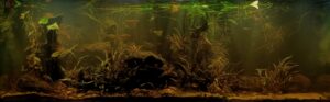
Volume of aquarium: 540L
Dimensions of aquarium: 180*50*60
List of fishes: Trichogaster Leeri
Chromobotia Macracanthus
Kryptopterus Bicihrris
Desmopuntius hexazona
List of plants: Cryptocorynes sp.
Nymphea SP.
Description of Decorations and Substrate: We found a sunken trunk similar to that of mangrove or mopani wood. Simulating a rotten trunk that falls, and when the lake rises, it is covered by water along with the cryptocorynes.
The stones and sand are rounded and beige but due to the algae they change their color.
Description of Equipment: 150 liter sump with eheim pump 2000 liters per hour.
jager heater 300w
SunSun lighting of 10,000k 4 spotlights of 20w
Water Parameters: The temperature is 26°C and its pH is 6.5 gh 8
Additional Info: In this aquarium we change 50% every 15 days, due to the organic matter created by the trunks and leaves.
Aquarium video::
Description of the Area Surrounding the Biotope: Danau Sentarum National Park (DSNP) is located in the Kapuas basin on Borneo (Kalimantan Barat province of Indonesia), in the area called Kapuas Lakes, about 700 river – km from the sea. DSNP is situated about between 0°40′ and 1°05’N and 111°56′ and 112°20′ E, at an average altitude of 40 masl. It was officially established as a wildlife reserve since 1982 (although effectively managed only since
1992) with an area of 80,000 ha and was designated as a national park in 1999 through Decree of Ministry of Forestry SK No. 34/Kpts-II/99, and its area increased to 132,000 ha plus a buffer zone of 65,000 ha (Giesen & Aglionby, 2000; Wadley et al., 2000).
The Kapuas Lakes area is part of the Kapuas floodplain, surrounded by hills. It is characterised by the presence of a maze of both seasonal lakes and permanent or temporary flooded forests and swamp forests which play an important role in buffering the water level fluctuations of the Kapuas main river.
The annual rainfall in the area averages 3500-4000 mm per year. The area is inundated for about 9 months of the year, particularly during the rainy north-east monsoon (beginning September or October). Towards the end of September or October, heavy rains begin to fall in the area and surrounding hills and the main rivers begin to overflow. From around December until April, the water level stays very high and reaches peak levels to up to 10-15 m in February and March. In the dry season, the water is gradually drained and in some years the lakes are completely dried. Depending on the altitude, the lakes will be dry for one to two months (July-August) in the year. In the rainy season, water from the Kapuas main river enters the lakes from different rivers and channels, while in the dry season the flow is reversed and the lakes are drained into the Kapuas. Villages in the Lakes Area are either on high piles on land, or consists of boats anchored along the lake shore. Some of the latter villages are
moved to different locations at different time of the year.
The lake waters are generally black waters (pH 4.0-5.5) as a result of deep peat deposits around the lake system. In fact, as a result of the topography (location and altitude) and of the connections with the Kapuas, there is great geographical and temporal variability in the water quality of different lakes.
Generally, the lakes further away from the Kapuas and at a higher altitude have permanent black waters.
Description of the Underwater Landscape of the Biotope: While the lakes which are closer to the Kapuas
exhibit fluctuations between black waters in the dry season when fed by water from upstream lakes and turbid, brownish water in the wet season when Kapuas waters enter the area.
The Kapuas itself changes from blackwater to murky, brown water depending on the rains in the hills or the Lakes area (as observed in early June 1995 in Sintang).
Vegetation maps usually indicate the Lakes Area as being covered by freshwater and peat swamp forests, but this is erroneous. The main vegetation type in the area is flooded forest, that is forest which is dry during a part of the year during which growth occurs. Swamp forest and peat swamp forests occur on soils which are permanently
water-logged and they are found at the base of the hill slopes.
Description of the Habitat Parameters: Water temperatures fluctuate between 24 and 34°C, with an annual average of 29.5°C.
pH 5.5-6.5
List of Fishes and Invertebrates Occurring in the Nature Biotope: We find many species in this lake
Balantiocheilos melanopterus
Eirmotus aff. octozona
Puntius everetti
Puntius rhomboocellatus
Rasbora dorsiocellata
Rasbora sarawakensis
Kryptopterus bicirrhis
Kryptopterus cryptopterus
Xenentodon canciloides
Datnioides microlepis
Toxotes microlepis
Luciocephalus pulcher
Trichogaster Leeri
Sphaerichthys vaillanti
Puntius hexazona
Betta bellica
I put the ones that I have had easier to find in commercial listings and that could live in aquariums, but the list is very long.
List of Plants Found in the Nature Biotope: We found several species of Nymphea SP. and cryptocorynes sp. On the banks and flood zones.
Threats to the Ecology of the Biotope: This lake, in addition to the contamination due to the human use of its resources, we see its environment seriously affected by the introduction of invasive species from other countries, which puts the calmer species at risk.
Sources of Information:
fish and information about the lake in:
inhttps://www.google.com/url?sa=t&source=web&rct=j&url=https://lkcnhm.nus.edu.sg/wp-content/uploads/sites/10/2021/01/S13_139-173.pdf&ved=2ahUKEwi9sKjS7cj1AhUqAWMBHaZ2CXsQFnoECAMQAQ&usg=AOvVaw3CxbDBm9tUkofe_RxA1RvM
Video inspiración