Intermediate Rocky Habitat, Makabola, Lake Tanganyika, DR Congo
_st place in Biotope Aquarium Design Contest 2022
Volume of aquarium: 96 litres
Dimensions of aquarium: 45x45x45 cm
List of fishes: Julidochromis transcriptus “Kissi” ( 1 breeding pair + 10 juveniles)
List of plants: None.
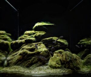
Description of Decorations and Substrate: I have collected natural curved and edged river stones (approximately 25kgs) from my nearby river. I have used an egg crate on the base of the rock to prevent the rocks from falling down. The sand is the coastal sand (approximately 10kgs) which is very fine and similar to the species natural habitat. I have positioned the rocks by getting inspiration from Biotope videos. The light source of the tank is from the top and I have used a black background to contrast the algae rocks in which the species dwell. Even I have created caves for the species to breed and rest.
Description of Equipment: Filter: Jeneca HOB XP-08, Heater-SOBO 75 watt, Lightning: Fireglow 21 watt
Water Parameters: Temperature is 25°C, pH is 8.8, gH is 11
Additional Info: I have used natural coastal sand on the bottom and used a buffer solution to raise the pH to 8.8. I clean 30% of the water and siphon the crevices of the rock weekly. During weekly water change I clean the algae on glasses and equipments with a sponge. I clean the filter in every 2 months. I feed my fishes high quality foods twice a day and maintained their balanced diet. I light my tank for about 6 hrs. Decoration of the tank and with healthy maintainance helps my fishes to feel like their natural surroundings and breed profusely.
Aquarium video:
https://drive.google.com/file/d/1RifGw_tb67irdSl27-ROwrls6xBwggb7/view?usp=drivesdk
Description of the Area Surrounding the Biotope: The Biotope is situated about 1200-1500 metres away from the shoreline. The shoreline is quite narrow with rocks and forrest covered hills. The Makabola village in DR Congo has an elevation of 796 metres.
Description of the Underwater Landscape of the Biotope: Underwater habitat of the Biotope is 10 metres deep. It is an intermediate rocky habitat which meets sand in the bottom. Rock sizes ranges from 1-2 metres. Algae is seen on rocks as a thick layer and sediment is found as dust on the rocks.
Sessile algae forms as biofilms over rocks. The sand is extremely fine in this area. There is a gradual inclination which starts from high rocks and ends in fine sand bottom. Rock piles creates shelter for different species. Mass existence of floating zooplanktons invites the shoal of fish to feed in this habitat. Mostly carnivore and omnivore species exist in the habitat. Water transparency is medium.
Description of the Habitat Parameters: Water transparency is medium, the average temperature varies from 25-27°C, pH ranges from 8.5-9.4 depending on the season.
List of Fishes and Invertebrates Occurring in the Nature Biotope: Bathybates vittatus, Benthochromis melanoides, Benthochromis tricoti, Boulengerochromis microlepis, Cyprichromis pavo, Cyprichromis microlepidotus, Cyprichromis brieni, lamprologus leleupi, lamprologus crassius, lamprologus niger, Julidochromis transcriptus, Julidochromis marlieri
List of Plants Found in the Nature Biotope: None.
Threats to the Ecology of the Biotope: Agriculture areas or any industrial factories are found in this region, so there is extreme danger in polution. However danger is created by human exploitation. The people of Makabola depends on fish protein and sells fish to earn some money in the Makabola Fish Market.
Overfishing can make the species go extinct from there natural habitat.
Apart from this, in last 100 years, global warming caused the surface temperature of the water to rise by 1.5 to 2.3° F. and in future it was reported by scientists to increase more.
Since Makabola’s population is increasing day by day human needs of the lake also increasing and has reached the end of the shoreline.
Deforestation, over-exploitation of the fishery and siltation caused by erosion from deforested areas are considered one of the main threats to the health of the lake.
Moreover, the natural habitats around the lake are destructed by the expansion of land use for agriculture or construction. Inadequate agricultural cultivation practices in the lake basin lead to land degradation and erosion. As a result, sedimentation becomes a major threat to the lake.
Pollution is another major threat to the lake. Industrial, craft and domestic waste from the cities and villages along the lake are directly discharged into the lake without any pre-treatment. Pollution is also caused by transport on the lake and fishermen using oil for generators and lamps during night fishing. In addition, the lack of sanitation infrastructure at landing stages of fishing boats also contributes to pollution; only 14 % of sites have public restrooms.
Given its global and local importance, special attention from the international community is needed. At the local level, the four riparian states have already established a cooperation framework called the Lake Tanganyika Authority
Unfortunately, these four countries are among the poorest countries of the world and not able to handle the situation on their own. Coordinated support is essential to improve the situation of the Lake Tanganyika ecosystem and the living conditions of riparian communities. An important next step would be that the four riparian states harmonise their laws and regulations towards a sustainable management of Lake Tanganyika.
Sources of Information:
1.https://en.wikipedia.org/wiki/Lake_Tanganyika
2.https://www.cs.mcgill.ca/~rwest/wikispeedia/wpcd/wp/l/Lake_Tanganyika.htm
3.https://www.sciencedirect.com/science/article/pii/S0380133019301066
4.http://lta.iwlearn.org/thelake_and_basin
5.https://edepot.wur.nl/121977
6.https://www.globalnature.org/36549/Living-Lakes/Africa/Tanganyika/Data/resindex.aspx
7.https://www.hindawi.com/journals/ijbd/2013/269141/
8.http://www.aquaticcommunity.com/cichlid/habitat.php
9.https://www.lakepedia.com/lake/tanganyika.html
10.https://www.sciencedirect.com/science/article/pii/S0380133019301066