Seversky Donets River, shallow place behind dam at the village of Eskhar, Ukraine
5th place in Biotope Aquarium Design Contest 2017
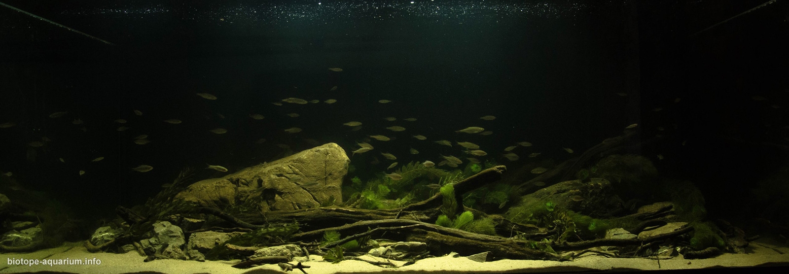
![]() Ukraine. Alexey Bureiko
Ukraine. Alexey Bureiko
Volume: 768 L
Dimensions: 160x80x60 cm
List of fishes: Alburnus alburnus, Ballerus sapa, Scardinius erythrophthalmus, Pseudorasbora parva, Rhodeus sericeus, Rutilus rutilus
List of plants: Myriophyllum spicatum, Potamogeton crispus
Description of decorations: Driftwood and stones in shape, texture, color are similar to those found in the biotope. Sand of the same fraction and color as in the river.
Description of equipment: Atman 2500 x2, Jebo 820, LED lights 20 W x 4
Water parameters: Temperature 20-24°С, TDS 370, рН 7.5
Description of the area surrounding the biotope: Seversky Donets is the largest river in eastern Ukraine. The total length of the river is 1053 km, the basin area is 98,900 km². Seversky Donets starts on the Central Russian Upland, near with Podolhi settlement in the Prokhorov district of the Belgorod region of Russia. The Seversky Donets feeds mainly from snow. The width of the river bed varies mainly from 30 to 70 m, sometimes reaching 100-200 m, and in the reservoir zone it is 4 km. The bottom of the riverbed is predominantly sandy, uneven, with a depth fluctuation of 0.3 m on the ruts to 10 m on the tufts. The river freezes in winter with a surface ice thickness of 20 to 50 cm. The freezing period is usually two to three months from the middle of December to the end of March. Both banks of the river in this area are high, riddled with ravines and ruts, densely covered with old maples and oaks, as a result of which there are a lot of driftwood on the bottom of the river. Also characteristic feature of this biotope is the presence of large stones imported for the purpose of cutting the water flow during discharge from the dam.
Description of the underwater landscape of the biotope: The river passes through calcareous rocks, as a result of which the water in it is rather hard (TDS 350-700), the bottom of the river is covered with sand, fraction 0.2-1.5 mm. Near the dam in the river there are a lot of stones brought in to cut the water flow. The river passes through the leaf forest, in consequence of which the bottom is strongly curved. Due to the presence of a large number of stones and driftwood, sandy soil, good illumination, constantly high water temperature (due to the confluence of the power plant cooler channel), in combination with strong currents, large thickets of aquatic plants can be observed.
Description of the parameters of the habitat: The water is transparent, turns green 2 times a year, at the end of May and in the middle of August. The average temperature in the summer is 18°C, in the winter it is 8-12°C (in consequence of the confluence of the power plant cooler channel). TDS 350-700. Water has a slightly alkaline reaction of pH 7.3-7.5.
List of fishes: Alburnus alburnus, Ballerus sapa, Rutilus rutilus, Scardinius erythrophthalmus, Squalius cephalus, Pseudorasbora parva, Rhodeus sericeus, Leuciscus idus, Perca fluviatilis, Esox lucius, Proterorhinus semipellucidus.
List of plants: Ceratophyllum demersum, Myriophyllum spicatum, Potamogeton crispus, Potamogeton lucens, Potamogeton gramineus, Stuckenia pectinata, Salvinia natans, Nuphar lutea, Nymphaea alba, Hydrocharis morsus-ranae, Pistia stratiotes earlier everywhere, now it is rare.
Sources of information: In consequence of the strong current in the dam area, underwater shooting is difficult. Above water: https://www.youtube.com/watch?v=DQUr0-HMIJc; under water: https://www.youtube.com/watch?v=ExI_ylrZG-g
Comments of the members of the jury of Biotope Aquarium Design Contest 2017

It is an elegant biotope of the northern river zone. I observed similar picture hundreds of times. Of course, the author thoroughly researched the site of this river in nature. I believe that those make the best and more reliable entries who studied certain biotope in nature, and not from photos and videos.