Floodplains, near the mouth of the Rio Manacacias River, Colombia
90th place in Biotope Aquarium Design Contest 2019
Poland. Krzysztof Szulczyk
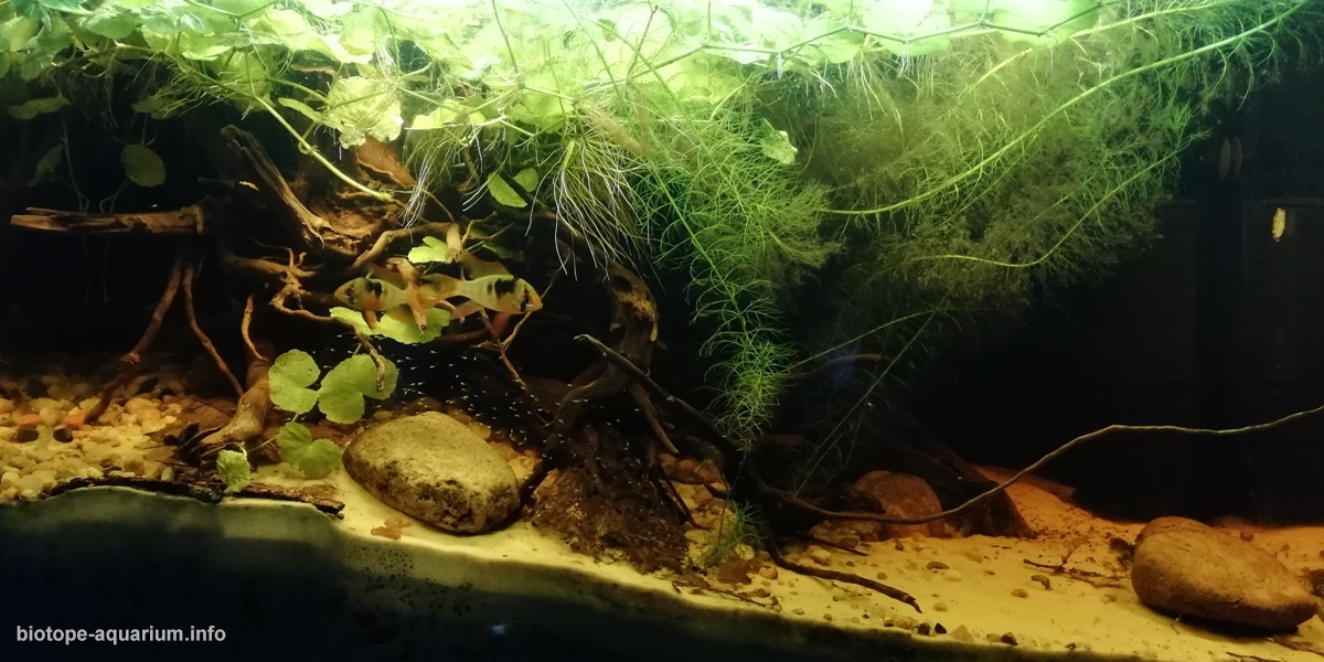
Volume: 63 L
Dimensions: 60x30x35 cm
List of fishes: Mikrogeophagus ramirezi, Rinelorricaria eigenmanni
List of plants: Myriophyllum aquaticum, Hydrocotyle leucocephala
Description of decorations: The bottom is made of quartz sand (0.1-0.3mm fraction), on the side of the hill between the quartz marker and the bottom of the aquarium natural gravel (3mm-30mm fraction) was used, in places where the vegetation was planted under the recorder, apart from the gravel there was a substrate from peat. On the hill, a natural root to imitate a fragment of a sunken tree and provide a place of residence / shelter for Rineloricaria eigenmanni, around the root there are leafed leaves and black alder cones (Alnus glutinosa Gaertn), as well as Ketapanga leaves and Ketapanga bark pieces. The bottom prepared in this way has several meanings, that is to say, bring the natural bottom closer to the appearance and cause the proper tea coloration of the water, providing appropriate elements such as tannins. On the right side, the part imitating the river bed, therefore the area is not planted with vegetation, only sand was used that fulfills not only a visual role, but also practical, because Microgeophagus ramirezi use sand to clean the gills and in the spawning period dig a hole into which they are transported fry, which is there to the momet when it is able to swim alone. I have also placed a flat stain, on which Microgeophagus ramirezi, after its prior purification, can spawn.
Description of equipment: LED lamp with a power of 18W and color 7500K, the period of illumination is 10h (in the range from 9:30 to 19:30). Internal filtration – sponge and peat insert (to maintain an effective pH), a rain shower located in the exposed part (right side of the aquarium) directed from the back towards the front of the aquarium to obtain the effect of the water current. Water flow 350l / h. Internal heating – 100W heater with thermostat.
Water parameters: Transparent water with tea color, thanks to the leaves used on the bottom and cone. Temperature 27 ° C, pH 6.0, KH 1, GH 3
Additional info: –
INFORMATION ABOUT BIOTOPE
Description of the area surrounding the biotope: The Manacacias River is located in the Meta Department of Colombia and is a tributary of the Meta River. The Apure basin covers a small part of the Colombian territory in the upper reaches of the Sarare River and its tributary Oirá. The upper springs of the Manacecias River are found in the Andes. Most of the Manacacias river basin is located on the vast Colombian – Venezuelan plain called Los Llanos, which is a highly productive cover of the ecosystem for the extensive savanna vegetation. After reaching the plains, the speed of water decreases and slows down. This large zone is seasonally flooded, which allows for a wide interaction between the Manacacias River and its flood plain. Interaction between river water and the flood plain plays a key role in mainstream ecology. The climate in Los Llanos is the climate of a tropical savannah and consists of wet and dry season. The rainy season starts in May and lasts until November, while the dry season lasts from around November to April. Months with maximum rainfall are June, July and August. In the high water level, the river floods its floodplains, which remain flooded until November. The hydrological cycle in the river is accompanied by large changes in the concentrations of the dissolved element. In the vicinity of Puerto Gaitan, the river connects with the river Meta. The river channel often turns and one of its banks is overgrown with forests when at the same time sandy beaches are formed on the other side.
Description of the underwater landscape of the biotope: While describing the underwater landscape, I suggested photographs of the surroundings of the river found on the Internet and satellite images of google maps. Combining this with descriptions of other places of occurrence of Mikrogeophagus ramirezi, I created a representation of the bottom which must consist largely of quartz sand occurring in the middle part of the river bed and its shore not covered with trees and vegetation, and on the other (where there is abundant vegetation) a mixture of sand and matter organic.
Description of the parameters of the habitat: The water temperature in the dry season reaches 28-29 degrees Celsius. The pH value depending on the distance from built-up areas (the farther the lower) is from 5.5 – 6.8.
List of fishes and invertebrates occurring in the nature biotope: On the basis of Global Biodiversity Information Facility, I built a list of fish found in the Rio Manacacias estuary: Mikrogeophaus ramirezi, Rineloricaria eigenmanni, Hemigrammus rhodostomus, Hyphessobrycon bentosi, Moenkhausia caudomaculatus, Nannostomus eques, Apistogramma hoignei, Aequidens diadema, Heros severum, Satanoperca daemon, Leporinus fasciatus. Of the larger species found in this region, Cichla orinocensis, Serrasalmus rhombeus, Pygocentrus cariba, Hoplias malabaricus can be mentioned. A little above, in Rio Meta we meet: Anostomus Anostomus, Apistogramma macmasteri, Mesonauta insignis. Below in Rio Manacacia, closer to the town of Puerto Gaitan we will meet: Apistogramma macmasteri, Platydoras costatus, Farlowella mariaelenae, Hypostomus plecostomus.
List of plants found in the nature biotope: Since I did not get to the list of plants found in the Rio Manacacias basin, I relied on the list of plants found in other areas where Mikrogeophagus ramirezi occur. On the basis of such a list, using the Global Biodiversity Information Facility, I checked their occurrence in the region of Rio Meta and the estuary of Rio Manacacias: Syngonanthus, Myriophyllum aquaticum, Hydrocotyle leucocephala.
Threats to the ecology: –
Sources of information:
https://en.climate-data.org/so
https://www.gbif.org/
https://domowe-akwarium.pl/akw
http://aquatic-experts.com/ESP
https://sv.wikipedia.org/wiki/
http://www.cormacarena.gov.co/
http://www.cormacarena.gov.co/