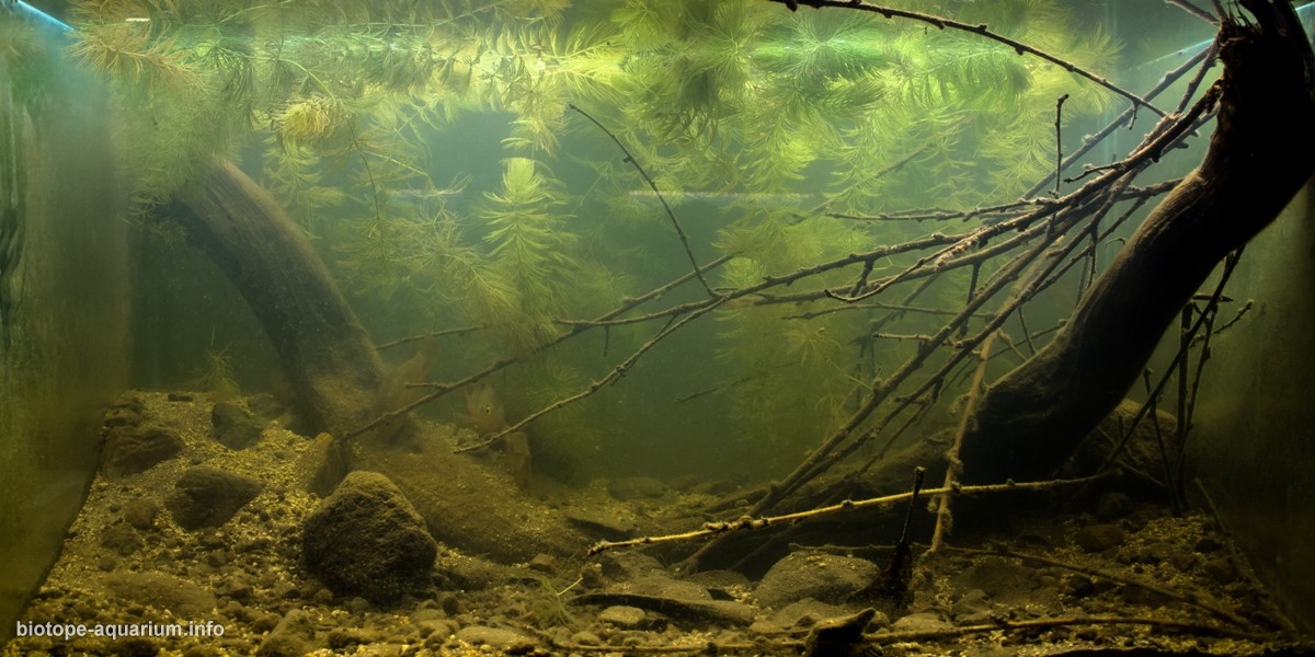
Shore of the Nahualate River in winter, Escuintla, Guatemala
79th place in Biotope Aquarium Design Contest 2019
Guatemala. Luis E. Pérez

Volume: 300 L
Dimensions: 100x60x50 cm
List of fishes: 5 Cribroheros longimanus
3 Poecilia mexicana
List of plants: Lemna minor, Salvinia minima, Ceratophyllum demersum
Description of decorations: All the decorative elements used (sand, rocks, plants, leaves and tree branches) were collected from the Nahualate River and were arranged for a more accurate representation of the represented biotope.
Description of equipment: Canister Fluval 307 with mechanical and biological material, Atman 150w heater, 3 tubes T8 6000k 1 tube T8 2700k
Water parameters: The temperature is 24° C, 0 ppm ammonia, 0 ppm nitrite, 20 ppm nitrate, 18 GH, pH 7.9, presence of tannins.
Additional info: Partial water changes of 30% weekly
INFORMATION ABOUT BIOTOPE
Description of the area surrounding the biotope: The Nahualate River account is located between parallels 14.00.32 “and 14.54.26” north latitude and meridians 91.09.20 “and 91.38.05” west longitude
Due to the extension of its surface (2,012,1167 km2) it occupies the fifth place (8.44%) within the basins that discharge its waters to the Pacific Ocean. It partially covers the departments of Escuintla, Suchitepéquez, Sololá and Totonicapán.
It has geographical boundaries, to the north the Motagua river basin, to the east the Madre Vieja river basin, to the west the Salamá and Siscán river basins, and to the south the Pacific Ocean to which it pours its waters.
The Nahualate River has a length from its source to the point of its mouth in the Pacific Ocean of 125,317 kilometers, along its channel it receives 16,098 streams, which means that the river basin has 8 streams per square kilometer of its surface.
Description of the underwater landscape of the biotope: Form and currents:
The shape of the basin appears quite elongated, with narrow parts to the north. Its average width according to the central region to the mouth is 25 kilometers, and at the top it goes about 25 kilometers until it has a convergence of 4 kilometers. The river has from very fast waters with presence of large rocks, to stagnant waters on some banks where the soil is sediment and mud with plants and leaves.
Depth:
On the river route you can see different underwater landscapes, from shallow waters of less than 1 meter to spaces where the depth can reach 5 meters (or more in the rainy season).
Elements that make up the underwater landscape:
A large number of trees border the banks of the river, providing to this, branches and leaves which are washed away by the current, which is combined with the ground formed by sand, small and medium rocks.
Description of the parameters of the habitat: The water is slightly cloudy and amber in color due to the amount of organic material that is decomposing, the pH is in ranges of 7.6 – 8, the average GH is 17, the average temperature is 23° C.
The parameters were measured with aquarium tests
List of fishes and invertebrates occurring in the nature biotope: In the place the following species were identified:
Amatitlania nigrofasciata (Günther, 1867)
Astatheros macracanthus (Günther, 1864)
Astyanax aeneus (Günther, 1860)
Amphilophus trimaculatum (Günther, 1867)
Cribroheros longimanus (Günther, 1867)
Poecilia Mexicana (Steindachner, 1863)
List of plants found in the nature biotope: Cabomba caroliniana
Lemna minor
Salvinia minima
Ceratophyllum demersum
Nymphaea tetragona
Threats to the ecology: • Increase in housing in areas near the river.
• Population increase, with children and young people being the most significant percentage.
• Intensive use of the river for irrigation, which also causes a greater degree of pollution.
• River used for drains and garbage dump of the towns on the edge of it.
• River deviation
Sources of information:
http://biblioteca.usac.edu.gt/
https://icc.org.gt/wp-content/
Exploration in the river.
